The corridor query parameter (1000–20000 meters, default 8000) controls how far off the route the optimizer looks for charging stations. Every station within that distance is a candidate; everything outside is invisible to the optimizer. A wider corridor means more candidates — often better chargers — at the cost of potentially longer detours and, for very wide corridors, driving-time estimates that are harder to guarantee. The same Amsterdam → Bremen request with corridor=1000 and corridor=20000:
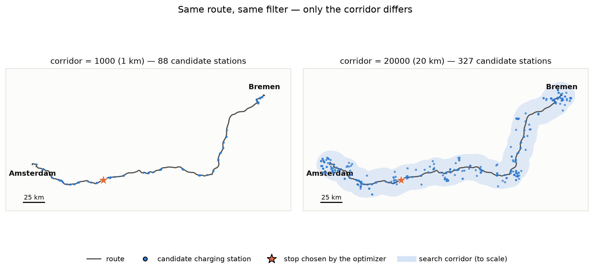
Two maps of the Amsterdam to Bremen route. Left: corridor 1000 m with 88 candidate stations hugging the route. Right: corridor 20000 m with 327 candidate stations spread in a wide band, including clusters around cities.

Request

curl -X POST "https://api.fryte.com/planner/v2?corridor=20000" \
  -H "Authorization: Bearer <your-token>" \
  -H "Content-Type: application/json" \
  -d '{
    "vehicle_id": "010160700001",
    "battery_level_start": 0.7,
    "section_list": [
      {
        "start_pos": [52.3700, 4.9000],
        "stop_pos": [53.0800, 8.8100],
        "payload_kg": 19300
      }
    ],
    "poi_info": {
      "min_kW": 150,
      "connector_type": ["CCS"],
      "truck_approved": "TT"
    }
  }'
import requests

response = requests.post(
    "https://api.fryte.com/planner/v2",
    params={"corridor": 20000},
    headers={"Authorization": "Bearer <your-token>"},
    json={
        "vehicle_id": "010160700001",
        "battery_level_start": 0.7,
        "section_list": [
            {
                "start_pos": [52.3700, 4.9000],
                "stop_pos": [53.0800, 8.8100],
                "payload_kg": 19300,
            }
        ],
        "poi_info": {
            "min_kW": 150,
            "connector_type": ["CCS"],
            "truck_approved": "TT",
        },
    },
)
print(response.json())
const response = await fetch("https://api.fryte.com/planner/v2?corridor=20000", {
  method: "POST",
  headers: {
    "Authorization": "Bearer <your-token>",
    "Content-Type": "application/json",
  },
  body: JSON.stringify({
    vehicle_id: "010160700001",
    battery_level_start: 0.7,
    section_list: [
      {
        start_pos: [52.3700, 4.9000],
        stop_pos: [53.0800, 8.8100],
        payload_kg: 19300,
      },
    ],
    poi_info: {
      min_kW: 150,
      connector_type: ["CCS"],
      truck_approved: "TT",
    },
  }),
});
const data = await response.json();
console.log(data);
using var client = new HttpClient();
client.DefaultRequestHeaders.Add("Authorization", "Bearer <your-token>");

var json = """
{
    "vehicle_id": "010160700001",
    "battery_level_start": 0.7,
    "section_list": [
        {
            "start_pos": [52.3700, 4.9000],
            "stop_pos": [53.0800, 8.8100],
            "payload_kg": 19300
        }
    ],
    "poi_info": {
        "min_kW": 150,
        "connector_type": ["CCS"],
        "truck_approved": "TT"
    }
}
""";

var response = await client.PostAsync(
    "https://api.fryte.com/planner/v2?corridor=20000",
    new StringContent(json, System.Text.Encoding.UTF8, "application/json")
);
var result = await response.Content.ReadAsStringAsync();
Console.WriteLine(result);

What changed between 1 km and 20 km

In the comparison runs behind the figure, both plans stop once — during the driver’s mandatory 45-minute rest — and both arrive in Bremen at practically the same time. The difference is what that stop is worth:
corridor=1000corridor=20000
Candidate stations88327
Chosen stopTango electric, Rijksweg A1Fastned, De paal
Energy recharged in the 45-min rest40.5 kWh90 kWh
Battery at destination31%40%
Arrival time12:4512:45
The wider corridor did not make the tour faster here — it made the same rest stop recharge twice the energy, so the truck arrives with 9 percentage points more battery for the next leg.
Responses to requests with a non-default corridor include a warning: with a very wide corridor, detours to far-away stations make the driving-time calculation harder to guarantee. Treat 8000 as the sensible default and widen it when station coverage on the route is thin.

Always set the truck-ready filter

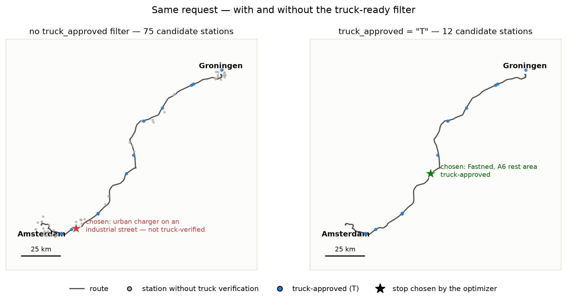
A wider corridor surfaces more stations — including urban chargers a 40-ton truck cannot physically use (access, turning radius, parking bay length). The optimizer only checks power and connector unless you tell it otherwise: set poi_info.truck_approved as the starting point of every truck request.
  • "T" — verified accessible for a tractor unit
  • "TT" — verified accessible for a truck with trailer (subset of T)
The same Amsterdam → Groningen request with and without the filter:
Two maps of the Amsterdam to Groningen route. Left: without the truck filter, 75 candidate stations including inner-city clusters; the chosen stop is an urban charger on an industrial street. Right: with truck_approved T, 12 candidates along the highway; the chosen stop is a Fastned A6 rest area.
"poi_info": {
  "min_kW": 150,
  "connector_type": ["CCS"],
  "truck_approved": "T"
}
Without truck_approved, plans can route trucks to stations that are not truck-accessible — this has happened in production with inner-city chargers around Amsterdam. If setting the filter returns not_drivable or very few candidates, the region may lack verified truck stations: widen the corridor, try "T" instead of "TT", or contact FRYTE about coverage — do not drop the filter for a truck.